



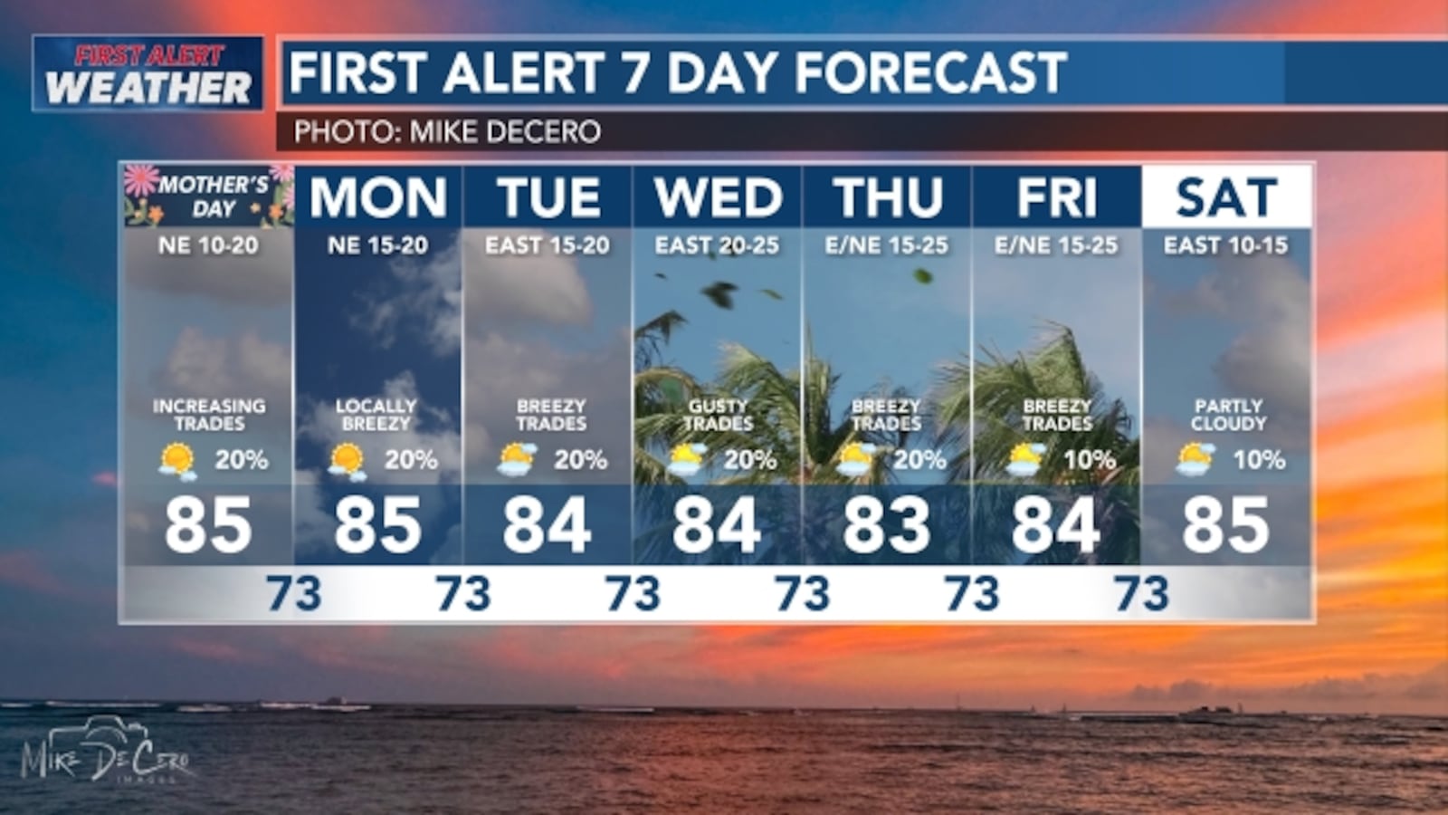
Mother’s Day in Hawaii is expected to bring strengthening trade winds, a few passing showers and mostly typical spring conditions, with forecasters warning that the breeze will likely turn noticeably gustier as the new week unfolds.
The overall setup points to a fairly stable weather pattern across the islands. A weak trough that has been influencing local weather is moving away, allowing trade winds to reestablish and gradually strengthen. That means many communities can expect a more classic Hawaii pattern, with clouds and brief showers favoring windward and mauka areas, especially during the overnight hours and early in the day.
For Sunday, the weather should remain manageable for most outdoor plans, including Mother’s Day gatherings, beach visits and brunch outings. While a few showers are still possible, especially in areas more exposed to the trades, widespread heavy rain does not appear to be the main concern at this point. Instead, the bigger weather story is the wind, which is expected to keep increasing.
By early next week, those trade winds are forecast to become moderate to breezy, and by midweek they could turn locally gusty in some places. That may lead to choppier ocean conditions, stronger crosswinds on open roads and a more persistent flow of quick-moving showers into windward neighborhoods. Leeward areas are still expected to stay drier overall, though stronger winds can occasionally push a few showers farther inland than usual.
Meteorologists are also keeping an eye on a possible upper-level disturbance expected to develop to the northeast of the state around the middle of the week. For now, its exact track and strength remain uncertain, so it is too early to say whether it will significantly change Hawaii’s weather. If it does have an impact, it could alter rainfall chances or slightly disrupt the trade wind pattern. At this stage, however, the more reliable part of the forecast remains the strengthening winds.
Across the western islands, some lingering moisture may keep shower chances elevated into Sunday before drier air gradually spreads in. As that happens, rainfall should become more focused in the usual windward and mountain areas rather than producing broad, unsettled conditions statewide. That will be welcome news for residents and visitors hoping for a more predictable stretch of weather heading into the week.
Marine conditions are also expected to reflect the stronger winds. The National Weather Service has indicated that fresh trade winds will continue to build, with rougher waters likely in typically windier channels and coastal zones. Boaters, paddlers and others planning time on the water should stay alert for changing conditions, especially around Maui County, the Big Island and windward waters where stronger winds can create hazardous seas.
Surf conditions remain relatively modest overall, but the pattern is likely to shift gradually as the trades strengthen. East-facing shores are expected to see a pickup in surf through the coming week, while south shore surf remains small. A small northwest swell is expected to linger through the weekend, but no major swell event appears to be driving the forecast right now.
There is also a seasonal beach advisory worth noting for Oahu’s south shores. This weekend and early next week align with the monthly period when box jellyfish are more likely to appear, with the highest risk around Sunday and Monday. Beachgoers are being urged to check local advisories, pay attention to posted warning signs and use caution before entering the water.
For air travel, stronger trade winds can also mean more turbulence in and around the islands, particularly near terrain and through common flight routes affected by low-level wind flow. While this does not mean major disruption is certain, it is another sign that the wind pattern will be one of the main features to watch in the days ahead.
Temperatures, meanwhile, are not expected to swing dramatically. Conditions should stay seasonable for May, helping maintain a comfortable feel despite the increasing breeze. In practical terms, that means the forecast is less about extreme heat or storms and more about a shift back into a windy, trade-driven pattern that many Hawaii residents will recognize.
The bottom line for Mother’s Day is relatively straightforward: expect a breezy day with passing showers in the usual windward and upland locations, while much of the state stays suitable for outdoor plans. Looking beyond the holiday, residents should be prepared for even stronger trade winds and more gusty conditions as the week goes on, with the greatest impacts likely to be felt along windward coasts, higher elevations and marine areas.